I'm going to attempt to be better at this so here's the first of a few recent trip reports.
Cypress Peak - 2083m / 6834ft
10-25-13
Party: + Paul Romero
Conditions: Unseasonably warm and sunny. Temps from 10 degrees in the shade and nearing 20 in the late afternoon sun. Some snow above 1700m / 5500ft still remained from a late Sept storm system.
Timing: 2h14m to the top and 1h45m down for 3h59m return. We spent approx fifteen minutes of stop time on the summit.
Total Distance: 5m / 8km
Total Elevation Gain: 1050m / 3500ft
Pace - Easy/Honest/Intense: Honest. A steady pace up with a few short breaks. An easier pace down with some additional time spent enjoying the sun and the views from the ridge.
Gear Used: Trail running gear with some emergency supplies
To The Trailhead: Drive time from Lonsdale in North Van to the trailhead was approximately 90 minutes
Access: Though the scrambles guide which was published in 2005 describes the road in as having waterbars and needing a high clearance vehicle one only needs to check their website Cairn Publishing for the addendum which as of 2008 accurately states:
The access road has seen some changes recently. Reportedly the road access is now accessible by a 2wd vehicle. In addition, the road now continues beyond the end described in the guidebook.
We drove all the way to the trail in a Honda Element with only one small hill near the very end offering any suggestion of needing an AWD vehicle.
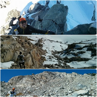
The Route: The first glimpse of some peaks that you spot on your left seems to line up with the images in the Scrambles Guidebook, when in fact this is the drainage that stares up at Tricouni Peak. You need only assess the water features for a second to realize you're not scrambling up that side. Tricouni is accessed from the Squamish Valley FSR on the opposite side of the range. Continue to the next drainage and there is a small pullout area on the left to park at. There is actually flagging tape on the left side and a maintained trail down to the Roe Creek crossing, which has even seen some very recent chainsaw work. From here you're on rock and in the alpine immediately. There are rock cairns guiding you initially but as they peter out you simply stay to the right of the glacial tongue you first encounter.
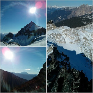
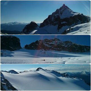
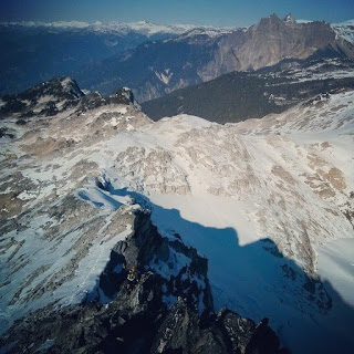
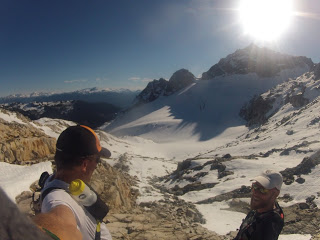
Route find your way into the basin above and then stay to the right of the glacier itself to gain the ridge crest. You'll be veering away from your target as you do this. Once you gain the ridge crest you have a straight shot along the ridge and up to the summit. The crux is a moderate 10m section at the base of the ridge. Everything beyond this is pretty straightforward.
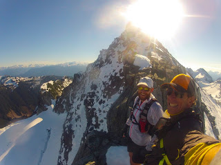
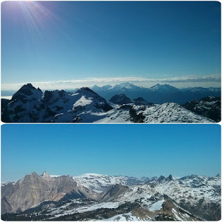
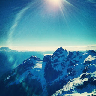
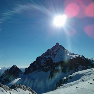
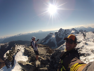
Summit views are nothing short of spectacular. The slightly higher Tricouni 2122m / 6962ft prevents sightlines down Howe Sound but otherwise the views are seemingly endless with glaciers in abundance, as is always the case in the coast mountains. Dramatic peaks such as Pyroclastic, Vulcan's Thumb, Cayley and Fee present themselves to the North. As you pan clockwise you scan across Wedge, Blackcomb, Overlord, Black Tusk, Table, Garibaldi, Tricouni, Mt. Tantalus, Pelion, Ossa, etc.
Assessment: A very worthy objective and though you may spend more time driving (from Vancouver or further) than you actually do on your feet, the route is fun and has a wild flare to it as it is without the standard long forested approach that most peaks on the coast demand.
GPS via Movescount: click here
Pictures:


GR
Cypress Peak - 2083m / 6834ft
10-25-13
Party: + Paul Romero
Conditions: Unseasonably warm and sunny. Temps from 10 degrees in the shade and nearing 20 in the late afternoon sun. Some snow above 1700m / 5500ft still remained from a late Sept storm system.
Timing: 2h14m to the top and 1h45m down for 3h59m return. We spent approx fifteen minutes of stop time on the summit.
Total Distance: 5m / 8km
Total Elevation Gain: 1050m / 3500ft
Pace - Easy/Honest/Intense: Honest. A steady pace up with a few short breaks. An easier pace down with some additional time spent enjoying the sun and the views from the ridge.
Gear Used: Trail running gear with some emergency supplies
To The Trailhead: Drive time from Lonsdale in North Van to the trailhead was approximately 90 minutes
Access: Though the scrambles guide which was published in 2005 describes the road in as having waterbars and needing a high clearance vehicle one only needs to check their website Cairn Publishing for the addendum which as of 2008 accurately states:
The access road has seen some changes recently. Reportedly the road access is now accessible by a 2wd vehicle. In addition, the road now continues beyond the end described in the guidebook.
We drove all the way to the trail in a Honda Element with only one small hill near the very end offering any suggestion of needing an AWD vehicle.
The Route: The first glimpse of some peaks that you spot on your left seems to line up with the images in the Scrambles Guidebook, when in fact this is the drainage that stares up at Tricouni Peak. You need only assess the water features for a second to realize you're not scrambling up that side. Tricouni is accessed from the Squamish Valley FSR on the opposite side of the range. Continue to the next drainage and there is a small pullout area on the left to park at. There is actually flagging tape on the left side and a maintained trail down to the Roe Creek crossing, which has even seen some very recent chainsaw work. From here you're on rock and in the alpine immediately. There are rock cairns guiding you initially but as they peter out you simply stay to the right of the glacial tongue you first encounter.
Route find your way into the basin above and then stay to the right of the glacier itself to gain the ridge crest. You'll be veering away from your target as you do this. Once you gain the ridge crest you have a straight shot along the ridge and up to the summit. The crux is a moderate 10m section at the base of the ridge. Everything beyond this is pretty straightforward.
Summit views are nothing short of spectacular. The slightly higher Tricouni 2122m / 6962ft prevents sightlines down Howe Sound but otherwise the views are seemingly endless with glaciers in abundance, as is always the case in the coast mountains. Dramatic peaks such as Pyroclastic, Vulcan's Thumb, Cayley and Fee present themselves to the North. As you pan clockwise you scan across Wedge, Blackcomb, Overlord, Black Tusk, Table, Garibaldi, Tricouni, Mt. Tantalus, Pelion, Ossa, etc.
Assessment: A very worthy objective and though you may spend more time driving (from Vancouver or further) than you actually do on your feet, the route is fun and has a wild flare to it as it is without the standard long forested approach that most peaks on the coast demand.
GPS via Movescount: click here
Pictures:
GR